TerraColor NextGen Frequently Asked Questions
- What does "15-meter resolution" mean?
- Can I see individual houses or cars in NextGen imagery?
- How new is the NextGen imagery?
- What is true color imagery and why is it important?
- What is an ocean mask and why is it used in NextGen's processing?
- What does cloudless or cloud-free really mean?
- At what map scales can NextGen imagery be used?
- Does NextGen offer complete coverage of the globe?
- Does NextGen have imagery of Antarctica and the Arctic Ocean?
- Do you provide terrain/elevation data to complement the NextGen imagery?
- Is NextGen available in Cloud Optimized GeoTIFF format?
- How is NextGen used in web mapping products?
- Does the GIS company Esri use NextGen?
- Is NextGen used in some NASA and USGS websites?
- Is there a 10-meter resolution version of NextGen?
- What if I don't need the full 15-meter level of detail?
- Does NextGen offer global images with bathymetric ocean fill?
- How can mosaics using many different images be made seamless?
- What is sun glint and how does it affect satellite images?
- How does sun glint affect satellite image mosaics of ocean areas?
- Is NextGen created using the "best pixel" method?
- Can NextGen be customized?
- How large is NextGen in file size?
- What is the easiest way to copy a subset of NextGen tiles from a larger set?
- Can I purchase NextGen imagery of a country or continent only?
- Can NextGen be downloaded via FTP?
- How large of a print can be made with NextGen?
What does "15-meter resolution" mean?
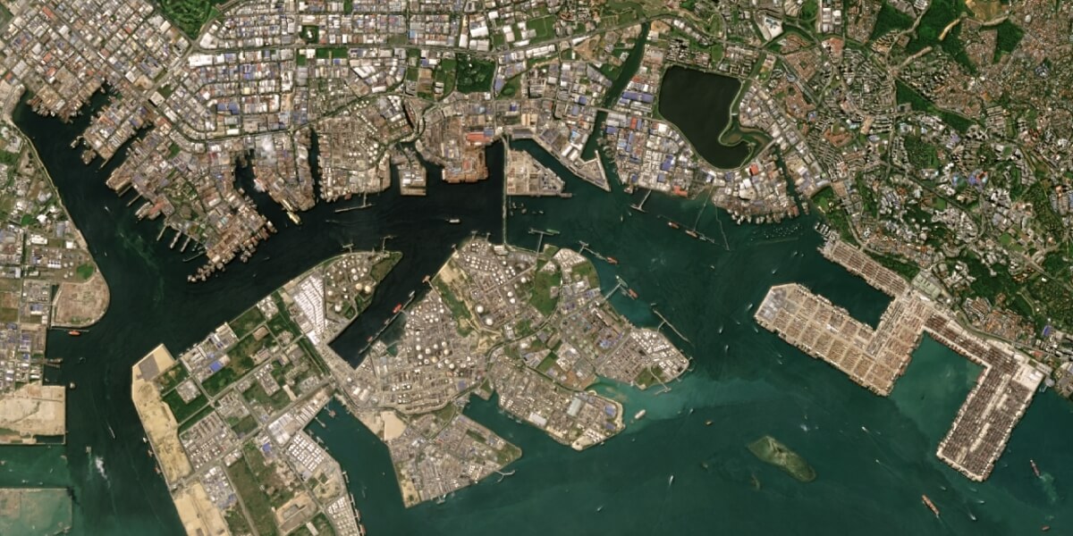
Resolution refers to the amount of detail in the imagery, and 15 meters refers to the ground dimensions of one pixel in the image. (So, one pixel covers a 15x15 meter patch of the ground.) This level of detail is sometimes called "medium resolution" and designed to create images of the complete globe all the way down to images of mid-size cities. Below is a full resolution snapshot of Singapore harbor:
Can I see individual houses or cars in NextGen imagery?
NextGen's 15-meter resolution does not provide enough detail to clearly see individual houses, cars, and similar smaller size features. For that, you need high resolution imagery, which is offered by other vendors.
How new is the NextGen imagery?
For much of the world the imagery dates are between 2014-2018. With our recent new release, we upgraded many key areas of the world with 2018-2019 imagery. For more details, see the Specifications page.
What is true color imagery and why is it important?
Most satellites image the earth in a variety of spectral bands (or wavelengths of light). Some of these are visible to the human eye (like green light) and some are not (like infrared light). A true color image is created when the image is built from the satellite's spectral bands corresponding to the red, green and blue wavelengths of light. Since the human eye is also sensitive to red, green and blue light, the NextGen image colors look "true" much the same as a person would see them from an aircraft. (Sometimes the terms "true color" and "natural color" are used interchangeably, but we prefer true color so there is no confusion.) Not all satellite images are true color, some vendors create false color images incorporating infrared bands, then manipulate the colors to try to make it look more natural (we call this "simulated natural color"). Since the colors cannot look truly realistic, sometimes you end up with strange artifacts like a blue patch in the middle of a desert where there is clearly no lake. This can cause problems in understanding the imagery, and it may not match well with other true color imagery of the same area.

What does cloudless or cloud-free really mean?
When evaluating products in NextGen's class, you'll often see the words "cloudless" or "cloud-free" used to describe the amount of clouds present in the imagery. In practical fact, products claiming to be "cloudless" do in fact have some clouds in areas with chronic cloud cover like the tropical equatorial areas or some oceanic island chains.
Many people think that all parts of the world have at least some perfectly clear "cloud free" days, but that is not the case. Building imagery with low cloud cover for those problematic areas requires piecing together parts of many scenes from multiple dates that have clouds in different parts of the imagery.
So, when we describe NextGen's cloud cover as "less than 0.5% globally" we mean that, on average, 99.5% of the pixels in the global coverage contain no clouds. Many large areas are 100% cloud free, while some other smaller areas may be only 90-95% cloud free due to persistent cloud cover. In addition, we never "paint out" clouds; 100% of the NextGen 15m imagery for land areas comes from real pixels in real images.
Does NextGen offer complete coverage of the globe?
Yes, unlike some other vendors, we offer off-the-shelf coverage of the entire planet with no gaps or holes. This makes NextGen perfect for virtual globe applications that require complete coverage of the earth.
Esri uses NextGen (with their own modifications) as the global satellite base map in many of their on-line web mapping applications, including ArcGIS Online (the Imagery basemap) and ArcGIS Earth.
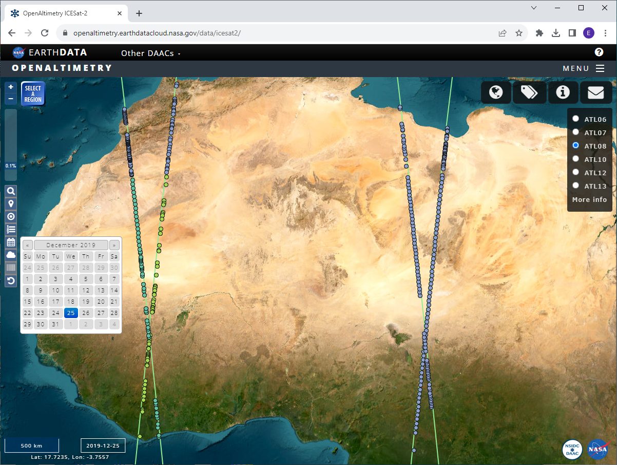
Via Esri, NextGen is used in several US government agency websites as a base map to facilitate access to a wide range of public domain geospatial data products. These include the USGS Earth Explorer and several NASA websites. Below is an example from NASA's OpenAltimetry website:

Yes, we have a 10-meter version which is initially created by resampling the original 15-meter imagery and then applying an enhancement to it. The 10-meter version is slightly sharper and crisper with a bit more local contrast. In addition, we also offer updates to the 10-meter version that are made with 10-meter Sentinel-2 imagery, so updated areas are true 10-meter imagery and not resampled 15-meter. If you are interested, please contact us for details.
Since some applications do not require 15-meter resolution or have very tight disk space requirements, we offer reduced resolution versions of NextGen sampled at 30-meters, 150-meters or any other resolution as needed at reduced pricing. We can work with you to figure out the best resolution fit, so contact us for details or samples.
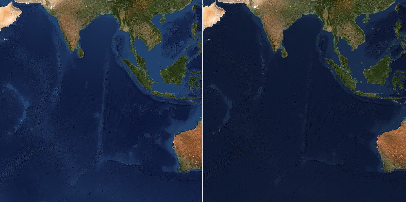
Yes, we offer a variety of bathymetric ocean fills by colorizing the bathymetric (ocean depth) data then applying relief shading to help make features easy to interpret. Usually darker colors represent deeper water and lighter colors represent shallow water. We offer several off-the-shelf options, or clients can specify their own custom color sets. Below are two samples:

Typical medium resolution satellite imagery mosaics are made using many images of the same area taken at different times of year to minimize cloud cover and for other reasons. Also, satellite images may appear brighter on one side due to the angle of the sun's illumination. If you mosaic images together without accounting for these differences, there will often be noticeable seam lines that limit use cases and detract from visual appeal. We compensate for these issues by using sophisticated tonal balancing software during the mosaicking process that evens out the brightness across the mosaic. Although it takes additional work, this processing creates a truly seamless mosaic that makes NextGen look like a single consistent image of the entire planet. Below is an image of the Amazon basin that shows a mosaic without color balancing on the left and NextGen on the right:

Sun glint is the specular reflection of sunlight off water surfaces, which can result in a "washed out" look in parts of satellite images. It is more noticeable on the eastern side of satellite images because of the sun's position relative to the satellite's viewing angle. While sun glint does not affect land areas, it can greatly affect the look and information contained in water areas. Below are two Landsat images of Andros Island, Bahamas taken in summer on the left (with significant sun glint) and winter on the right (with minimal sun glint).

Satellite images contaminated by sun glint are generally not useful in ocean area mosaics because of the loss of information about surface and subsurface features, and the difficulty in matching them to adjacent images without sun glint. For that reason, we incorporate images with minimal sun glint (such as during winter) to make sure that all water areas are portrayed correctly and appear seamless and consistent. Below is an image of Australia's Great Barrier Reef that shows a mosaic with sun glinted images on the left and NextGen on the right:

No, NextGen is created by using the best available scenes and compositing them with other scenes where needed to reduce cloud cover and improve quality. We feel this is the best way to precisely control the process and avoid introducing visual artifacts that may make the imagery unsuitable for some use cases and applications.
Products created with the "best pixel" method have the advantage of selecting the least cloudy pixels (which in some cases may still be clouds). However, this process can also introduce noticeable artifacts such as holes or blocky areas of mismatched color. In addition, because these products are created entirely by automated computer programs, they are not curated or improved by human beings and generally do not incorporate additional features like ocean masking.
Yes, we can customize NextGen to suit your needs or create a unique look. The two most common ways to modify the original NextGen product are changes to the overall brightness or contrast, and replacement of ocean areas with a bathymetric shaded relief image or other images or ocean colors. You can provide us with your own ocean images, or we can create them for you. Please contact us with your ideas and we can discuss the options in more detail.
In an uncompressed file format like GeoTIFF, the total file size for the NextGen global coverage is 5.5 TB (5,500 GB) for all tiles containing some land. In Cloud Optimized GeoTIFF or lossless JPEG2000 formats the file size is significantly less due to image compression.
Some users who have already purchased NextGen imagery asked how they can copy out a subset of images from a larger set. Manually dragging and dropping images from one folder to another may be OK for smaller sets, but is slow and painful for larger or more complex sets. To help with this, we developed a method to use the free software QGIS to help you select the tiles you want to copy from a map display, and then use a batch file to run the copy process. Click Here to download the instructions in PDF format.
Yes, you can purchase any area of the world. You can specify the country or region, use Lat/Long bounding box coordinates, or provide us with a Shapefile or KML file showing the desired coverage. See the Ordering page for details.
Yes, we usually deliver NextGen via FTP download links. Large sections or the complete global coverage can be downloaded via FTP (with some lead time) or can be delivered on an external hard drive at no additional cost if that is preferred.
If printed at 300 dots per inch (dpi), you could use the NextGen full global 15-meter coverage to make a print about 220 meters in width by 110 meters in height (720 x 360 Feet). Or, Australia at 25.6 x 13.4 meters (84 x 44 feet).
